
Thompson Creek trail is not heavily used at all. We saw almost no signs of any recent use. The trail is a bit foreboding on a map as it ascends almost 1800 feet vertically in just 2.4 miles. Both our topo map and our pisgah forest trail map show this trail as ascending right up the center of Thompson ridge. This is no longer accurate. After crossing the tributary the trail ascends along Thompson Creek – rarely going out of sight of the water. At the cross trail we backtracked to see how far our topo map was off. The old trail along the ridge is still there and can be fairly easily discerned (with some minor bushwhacking). The trail up to the Pisgah Inn also still exists. The traverse across the Thompson Creek headwaters is the most difficult portion.

The lower portion of Thompson Creek was completely hemmed in by flowering mountain laurels. The trail starts just across from the Pink Beds and the laurels definately carry over. The ascent along the creek is not really all that bad. The hideously steep bit is a series of switchbacks onto Laurel Mountain near the top of the trail. We had hiking poles with us and still found this very challenging. Ultimately, the Thompson Creek trail ends at the Pilot Rock trail about a mile from the Blue Ridge Parkway.

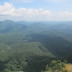
Instead, we turned south and came back down on the generally easier Pilot Rock trail. There are some difficult rocky switchbacks on this trail and it’s amazing that mountain bikers managed to make it down and across some of the boulder fields. The trail traverses the top of Pilot Rock which we more or less completely failed to notice. Ok, that’s not exactly true. We stood there for a moment and wondered if this were the top of Pilot Rock and then decided it wasn’t dramatic enough so we moved on. Oh well. The roundtrip hike with the forest road is about 6 miles. We also followed parts of the old abandonded trail just because it was on the 1986 topo quad.