Coontree Mountain

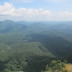
For this hike we parked at the Pisgah Forest stables. We did this apparently because we like to be bothered by horseflies while getting our stuff together. We followed the road to the Bennett Gap trail, followed it north through the junctions with the Coontree loop and continued on to a random highpoint past Coontree Mountain somewhere along Bennett Gap trail. From there we backtracked to Perry Cove and followed that trail back to Avery Creek. The views are probably better in the winter but they aren’t bad. John Rock and Looking Glass Rock are well-situated. This is the view to the northeast towards Clawhammer Mountain.

View from Coontree

This is a good hike to do if you hate your ankles and wish to punish them. Maybe your knees as well. The ascent up Bennett Mountain is actually long but relatively gentle. Once the trail merges with Coontree Loop there are a couple ascents that probably register on the rock climbing difficulty scales. There’s another of those ascents after the saddle that the Perry Cove trail comes out of. North of Perry Cove the trail is along a narrow rocky cliff edge where we stopped to rest and take in the semi-obstructed views.

Bennett Gap Trail

Perry Cove is a wicked descent. We did the hike in this order after looking at it on a topo map. I don’t think I’d really want to climb up Perry Cove. It’s an interesting trail though that covers hardwood cove, some open meadows, several wet stream crossings, old road beds and some great wildflower vales. This is a showy orchus. There is only one plant in this picture so that I don’t have to figure out what the plural of ‘orchus’ is.

Showy Orchus

The loop plus the viewpoint is probably around 4 – 4.5 miles with around 1100 feet of ascent.

Barnett Knob

First a note of warning – this is not a very interesting hike. In fact it’s probably not even worth an entry. Barnett Knob is one of those lookout towers we’ve driven past on the BRP a dozen times and so we finally decided to hike up and check it out.

Barnett Knob

This is just a few miles from the southern terminus at Cherokee/Smoky Mountains NP. There’s a forest road up to the summit but not much of a view once you get there. Some nice wildflowers along the way is about the best we can say for this hike.

Indian Paintbrush

Bridal Veil Falls

Bridal Veil Falls is located in the southern portion of DuPont State Forest. It’s really more or less out in the middle so there are many ways to get there from all of the access points. I don’t believe there is any way to get there that is less than a couple miles on trail though. We chose the Fawn Lake access and followed Conservation Road which takes you up across an old airstrip and then down through an old farm to the river.

Bridal Veil Falls - Upper

It’s difficult to see the whole of Bridal Veil Falls. There’s an upper section in this photo then it sort of curves off to the right along a long frothy chaotic rock slide. At low water like this it’s easy enough to climb up the edge of the falls. We should probably point out that they call this slickrock for a reason. Footing is great, as long as the rock is dry, otherwise it’s like ice.

Bridal Veil Falls - Bottom

There are lots of rocks around the bottom of the falls and even some decent swimming holes. Well they looked like they might be. We had the youngster with us so we mostly sat on the rocks and spent time setting up photos designed to look alarming – like this one.

Five-lined skink

Melanie took her usual array of nice wildflower pictures. However this skink came and sat next to us on the rock so instead of the crested dwarf iris picture we’re ending with a lizard instead.