We’ve passed Fryingpan Mountain about 100 times without ever hiking up to the tower on top. It’s located just about a mile down the Blue Ridge Parkway from the Pisgah Inn.
Fryingpan Tower
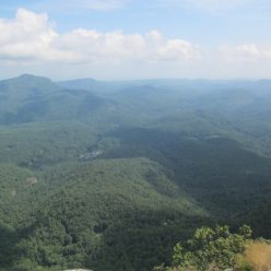
The hike is a little less than a mile up a forest road, not particularly interesting in itself. The tower was closed for renovations when we went up there but the view is still impressive, especially during the peak of Autumn colors. The view below is looking south towards Pilot Mountain.
View from Fryingpan
Besides being an easier hike the view is much better than from Mt. Pisgah which is completely covered in large towers.
The Chimney Tops trail on the Tennessee side of the Smokies is a popular one with good reason. This is actually the most crowded trail we’ve been on in a long time. The peaks are quite noticeable from the Tennessee side of the park near US 441.
View of the Chimney Tops
The trail is about 2 miles with something like 1300 feet of elevation gain. It’s a constant climb although there are some very scenic river crossings along the way. There are good views of Mount Mingus and Mt. Le Conte. The highlight of this trail though is the finale which is a rock climb to the top. There are signs warning of this at the trailhead but they don’t really show off the exposure of this rock face. Near the summit it becomes apparent just how much prominence there is to the west.
Chimney Tops Summit
Probably less than 20% of people hiking up the trail actually climbed to the top. The views are good although honestly they aren’t all that much better than other nearby peaks. There were about 10 other people on the summit which is relatively close to capacity. It does feature 360 degree views but it isn’t a very large area and there are couple of very exciting crevices to avoid.
This section of the A.T. runs 7 1/2 miles from Stecoah Gap at NC 143 to Yellow Creek Road. It’s not the most exciting section but we it was a bit we hadn’t done yet.
David on the AT near Brown Fork Gap
There are two waypoints of a sort along this stetch. One is Brown Fork Gap which has a shelter just above it. We stopped for lunch here. Coming northbound to this shelter you’ll have just completed the fairly hideous climb out of Sweetwater Gap. The next site of interest is Cody Gap which is also a reasonable campsite. In between is a high ridge with some great views of Lake Fontana and the Smoky Mountains.
These two falls are only about a 10 minute hike in from NC 215 and are practically visible from one another. It’s a little difficult to find the unmarked trail to them though. There are better descriptions out there but if you look at any good hiking map of NC 215 north of the Blue Ridge Parkway there is a hairpin turn just west of where Sam Branch and Wash Hollow meet. You can park in this turn and just up the road from there is a very steep trail up the embankment. After the initial climb, it’s quite an easy trail to the falls on Sam Branch.
Falls on Sam Branch
The falls at Sam Branch is a long series of cascades down an irregular cliff. The trail approaches this waterfall pretty much right in the middle. The continuing trail is directly across the waterfall from where the trail ends. At high water this is probably an impossible crossing. This is where we say waterfalls are dangerous. This is a relatively advanced crossing and depending on the location one choses to do it, there can be pretty serious consequences for a slip or missed jump. People die on waterfalls in western NC every year. If you die on a waterfall we can guarantee the Asheville Citizen Times will jump all over the story and run it for three or four days while assorted people who never leave their couch will ridicule you in the commentary section. You don’t want that, so don’t attempt to reach Wash Hollow Falls if Sam Branch has a lot of water in it.
Falls on Wash Hollow
Having said all that, Wash Hollow is a very nice location. There’s a lovely pool at the bottom and plenty of rocks and logs for a picnic. This is also the end of the trail. You can reach the top of these falls but it’s steep, treacherous and the view is much better from the bottom anyway.
Cedar Rock Creek Falls is an easy waterfall to find and an easy hike as Pisgah waterfalls go. It’s located about 0.8 miles south of the Davidson River Fish Hatchery. Park there, cross the bridge and take the trail immediately to the right. Following Cat Gap trail it’s pretty much impossible not to notice the falls down in a cove on the left side of the trail.
Cedar Rock Creek Falls
This falls seems to make a lot more noise than you’d expect for the size of it. It has a nice pool at the bottom that we had no interest in attempting after a 40(F)-degree night in the forest. There is also a sheltered cave just before the falls.