Archive for June, 2009

Gage Bald

Saturday, June 27th, 2009

This entry could be called Round Butt Bald because that’s the mountain we circled but since we didn’t summit it that seemed wrong.

Wet Camp Gap

Wet Camp Gap

From Bearpen Gap on the Blue Ridge Parkway we took the connector trail to the Mountains-to-Sea trail and followed that to Wet Camp Gap. Wet Camp is a high open meadow filled with blueberries, blackberries and assorted wildflowers. There’s also a small pond in the center but it was mostly empty on our visit except for a couple remnant pools that were packed with tadpoles.

Summit of Gage Bald

Summit of Gage Bald

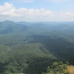
There’s an unofficial but easy-to-find trail leading southwest out of Wet Camp Gap. This eventually becomes a steep manway to the summit of Gage Bald where there are excellent views of the surrounding mountains. We had a bit of a picnic up here. By the way, these little sling chairs are incredibly light but they’re a bit tricky to set up and it’s definately a learned skill to get out of them with any modicum of grace.

Swallowtail and flame azalea

Swallowtail and flame azalea

Usually we expect to be scratched up after any sort of bushwhacking. We were after this hike but it wasn’t from Gage Bald, it was actually from the MST heading around Round Butt Bald back to the Blue Ridge Parkway at Haywood Gap. This section is narrow and treacherous, especially overgrown with blackberries and nettles. At the high point on this trail we considered hiking up to the summit of Round Butt Bald. The east approach to the top was pretty much a wall of blackberries and after donating some blood to them we abandoned the attempt and decided to try some other time in a less-summery season (like say, winter).

Green Knob

Monday, June 15th, 2009

Green Knob is located just off the Blue Ridge Parkway a little north of Mt. Mitchell State Park.

Green Knob Firetower

Green Knob Firetower

It’s a half mile hike from the parkway or it can be reached from the Black Mountain campground which is much longer and more arduous. There’s not much of a view on the way up but the tower is situated to give a spectacular view of the Black Mountains.Inside Green Knob Fire Tower

Inside Green Knob Fire Tower

Inside Green Knob Fire Tower

 The tower is open to hikers and slightly more comfortable than the rocks below it.    The top of the trail is overgrown in the summer and requires a bit of pushing through rhododendrons.  The view is also partially occluded in June, so it’s probably a better trip in early Spring or late Autumn.

Setrock Falls

Sunday, June 14th, 2009
Setrock Falls

Setrock Falls

After the short hike to Roaring Fork Falls we drove over to the Black Mountain campground.  The setrock trail branches off of a campground road and once the trail starts it’s only about a quarter mile to the falls.


Setrock Creek

Setrock Creek

There’s a shallow rocky pool at the bottom of setrock falls so it’s not as good for swimming as roaring fork is.  From here, we headed up to the Blue Ridge Parkway

Roaring Fork Falls

Sunday, June 14th, 2009

Roaring Fork Falls is located in the valley east of the Black Mountains.  There is parking just outside the Busick Work Center and after about a half mile of forest road, the trail to the falls leaves across a footbridge.

Roaring Fork Falls

Roaring Fork Falls

 The falls is a long series of cascade dropping about 100 feet total.  There is a particularly nice pool at the bottom if you can get over the frigid water temperatures. 

Roaring Fork Falls

Roaring Fork Falls

On our visit it was a relatively sunny day but the waterfall is located in a deep narrow valley and not a lot of light makes it down there.   The log on the right side of this picture is actually bolted to the rock.  We’re not really sure why as the view isn’t any better.

Thompson Creek / Pilot Rock

Saturday, June 6th, 2009
This hike was a loop where we parked at Grassy Cove, walked a mile along Yellow Gap Road to the Thompson Creek trail, followed this up to the top end and returned to Grassy Cove on the Pilot Rock trail.
Thompson Creek trail junction

Thompson Creek trail junction

 Thompson Creek trail is not heavily used at all.  We saw almost no signs of any recent use.   The trail is a bit foreboding on a map as it ascends almost 1800 feet vertically in just 2.4 miles.   Both our topo map and our pisgah forest trail map show this trail as ascending right up the center of Thompson ridge.   This is no longer accurate.  After crossing the tributary the trail ascends along Thompson Creek – rarely going out of sight of the water.  At the cross trail we backtracked to see how far our topo map was off.  The old trail along the ridge is still there and can be fairly easily discerned (with some minor bushwhacking).  The trail up to the Pisgah Inn also still exists.  The traverse across the Thompson Creek headwaters is the most difficult portion.

Mountain Laurel tunnel

Mountain Laurel tunnel

The lower portion of Thompson Creek was completely hemmed in by flowering mountain laurels.  The trail starts just across from the Pink Beds and the laurels definately carry over.   The ascent along the creek is not really all that bad.  The hideously steep bit is a series of switchbacks onto Laurel Mountain near the top of the trail.  We had hiking poles with us and still found this very challenging.  Ultimately, the Thompson Creek trail ends at the Pilot Rock trail about a mile from the Blue Ridge Parkway.

Speckled Wood Lily

Speckled Wood Lily

Instead, we turned south and came back down on the generally easier Pilot Rock trail.  There are some difficult rocky switchbacks on this trail and it’s amazing that mountain bikers managed to make it down and across some of the boulder fields.   The trail traverses the top of Pilot Rock which we more or less completely failed to notice.   Ok, that’s not exactly true.  We stood there for a moment and wondered if this were the top of Pilot Rock and then decided it wasn’t dramatic enough so we moved on.   Oh well.   The roundtrip hike with the forest road is about 6 miles.  We also followed parts of the old abandonded trail just because it was on the 1986 topo quad.