Max Patch

Ok, so we were just at Max Patch a few months ago.   However, since we were unable to get up the road to Snowbird Mountain, which was our intended hike, we came back to Max Patch.  

Max Patch View

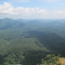
As always, the views are superb.   The meadows had recently been mown so there was more picnicking and camping than usual on the summit.   We hiked up to Max Patch along the Appalachian Trail from where it crosses the forest road.  After summitting, we followed the trail back down through a patch of forest.  Ultimately it follows a series of meadows that make up an equestrian trail on a parallel ridge. 

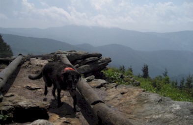
Roaring Fork Shelter is only a couple miles north of Max Patch Road.  It doesn’t have direct access to the Roaring Fork river but you’ll have crossed the stream a couple times getting there and its a good place to stop for a snack.

Trout and Mountains

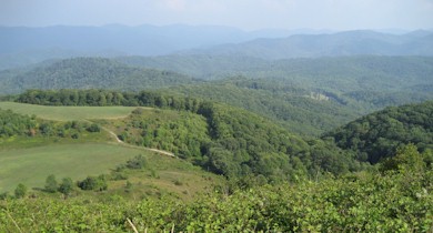
On the hike back, we followed a combination of the equestrian trail and the Max Patch loop trail which stays below the summit but still crosses some big meadows and has excellent views into North Carolina.  Trout found meadow hiking to be altogether confusing as it’s difficult to determine where the trail is.

Southern Brewers Festival

Beer festival season peaks in the southeast in September and October but there’s a few outliers.   Chattanooga’s Southern Brewers Festival is one of those.  It’s held in August when it is roughly 150 degrees in Chattanooga.

Melanie, a beer and the Tennessee River

It’s a token-based beer festival, which means you have to buy a token for each beer.  A token costs $3 so a beer isn’t really a trial size which discourages too much experimentation (only one of our beers ended up in the Tennessee River).  Most of the festival is up along the edge of the city, but the river is more scenic so that’s what we have in the picture.  A nice thing about this festival is that it runs for 11 hours!  So, we arrived in Chattanooga, checked into a downtown hotel and came to the festival for several hours.  In the afternoon we went back and took a nap and then came back for another round.

Krystals

As beer festivals go, the entertainment was pretty good.  In the afternoon things were pretty laid back.  There was a qualifying round for the Krystals World hamburger eating championships.  If you’ve ever seen any competitive eating on TV with that annoying announcer in the carnie hat, let me just say he’s 10 times more annoying in person.   Incidentally, one has to eat 51 Krystals in 10 minutes in order to win a giant trophy.   On the plus side, they handed out the uneaten Krystals afterwards and we can report that after several beers, Krystals actually taste pretty darn good.  

N. Mills River Trail

This hike started and ended at the Hendersonville Resevoir parking area. If you head south from the trailhead, the Trace Ridge trail leads down to the N. Mills River. The last tenth of a mile or so of this trail is extremely steep. It meets the river trail near the confluence of Wash Creek at a very pretty spot.

Wash Creek

The Nat’l Geographic Pisgah map shows the N. Mills trail ending here but it actually extends to the east as far as Yellow Gap Road. To the north and west, the trail runs for about 2 miles to meet a forest service road which connects back up to the trailhead. We did this hike during the drought (yet another drought) due to the high number of river crossings it entails. In fact, we counted 10 river crossings (11 if you start at Yellow Gap Road). One of these has a suspension bridge option, but the rest involving wading. A couple of the crossings were knee deep, even at very low water levels. There are quite a lot of good swimming holes along this trail and it’s a rather popular fishing spot as well.

Mills Crossing

Mt. Craig

We’ve been lax about posting our hikes here lately, so even though this is a short one we’ll include it so we don’t appear to be dead or abducted by aliens.
The Black Mountain Crest trail is notoriously difficult. While we’ve hiked south from Mt. Mitchell back as far as the Blue Ridge Parkway, we hadn’t gone north on the BMCT yet. Our original intent was to travel several miles out. Upon leaving Mt. Mitchell the trail immediately drops several hundred feet. It then runs along a ridge before ascending up to Mt. Craig – the second highest peak in the Eastern US. This is where a rather sudden thunderstorm caught us. This picture is of the trail itself. Not a creek bed.

black mountain crest trail

 A 6000 foot ridge with sheer cliffs on either side is no place to be in a thunderstorm.   With no better option we spent half an hour or more crouched in a grove of spruce trees.   When the storm passed we were drenched.  Worse than that, the already difficult trail was now slickrock with water streaming down it.  We decided we should at least finish summiting Mt. Craig.     It turns out that just 100 feet up the trail or so was a huge rock overhand that would be useful in future pop-up storms.

BMCT

The view from Mt. Craig is worth the difficult, if short (1 mile each way) hike.  From the top you can see… well, we could see cloud.   Eventually the clouds cleared long enough for us to snap a few pictures and see the daunting line of thunderstorms across the western horizon making their way towards us.   Reluctantly we decided that it just wasn’t a good day to be hiking on the highest ridge around and we headed back to Mt. Mitchell.   We actually reached the car just seconds before driving rain started again, followed shortly by hail so perhaps that was a good decision.

Mt. Craig