TurkeyPen

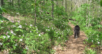
The TurkeyPen trailhead is in the southeastern corner of the Pisgah Ranger District.  It’s got a couple advantages – first there’s a ton of interconnecting trails here so it’s pretty easy to customize a loop of the size you want.   That’s actually a rarity in western NC.     Secondly, many of the trails run along rivers and creeks so it’s a good area when it’s hot out, or when your dog wants to spend all day lying in rivers and creeks.

Mills Crossing

Our dog wanted to spend all day lying about in creeks.   This is the Mills River.  It’s an important feature of the Turkeypen area because several trails cross it.   Most of them literally just run into the river and continue out the other side (see it over there?).   If there’s been a lot of rain recently this can be a very wet proposition.

Bridge

There is one suspension bridge over the river.   Dogs apparently are not fond of swinging bridges.    There were quite a lot of people in the area during our hike.   Probably more than half of them were fishing along the Mills so we only saw a handful of other people along the trails.

snake

We did come across this snake though.   It’s impossible to tell from this picture but this was actually about a 4 foot long snake.  We think it was a racer and it was probably either pregnant or it had just eaten one of those annoying yap dogs we’d passed earlier.   Kudos to the snake either way.

Big Ridge / SlickRock Trail

This was actually sort of a composite day in the Pisgah Ranger District.   We started out hiking along the MST from Big Ridge Overlook.   It looks pretty impressive and much like most of the overlooks around here.

Big Ridge

After this hike we went down to Slick Rock Falls which is an easily accessible waterfall.  It’s visible from a dirt road in the Looking Glass area.  In fact the trail (which we also hiked) goes up to several of the rock climbing routes on the west side of Looking Glass rock.  

Slick Rock Falls

Brown Gap to Max Patch

butterflies

Before our hike we spent a little time along Cold Creek in the Harmon Den area. There were hundreds of butterflies drawn to the salt deposits along the road so we have a few dozen pictures that look like this.

Orchid

Mid-May is a great time to hike in the area because of the wildflowers. We headed north bound on the A.T. from Brown Gap, which starts with a decent climb but is relatively gentle and rolling after that.

Trilliums

The trilliums were particularly abundant.   They’re a bit hard to see in this picture but all those specks of white and pink are trillium.   It was pretty much deserted on this part of the mountain until we reached Max Patch.  We decided not to climb to the top on this particular day.   Instead we let Trout lie in a stream and cool off while we studied the map.  

We decided we could take an alternate route back to Brown Gap.   This started by taking the A.T. southbound for a quarter mile or so to the junction with the Cherry Creek Trail.   We then took the Cherry Creek trail for maybe a half mile or so until it intersected an old forest service road (named 3533 on some maps).  We left Cherry Creek Trail and followed the road along the ridge.  This worked out great for a while at least.  The road was broad and easy to follow and it was paralleling the A.T. about 200 ft below it.  This is how it looked with a dog in the middle:

Forest Road

About halfway back to Brown Gap the road ends. This was not entirely unexpected as our A.T. map also showed the road ending. Our plan was to orienteer from here by following the 4000 ft. contour line around the ridge until it intersected the A.T. which would be descending towards Brown Gap at that point. Even in May the forest was pretty thick and there was a lot of sharp foliage (blackberries in particular). So when we encountered a really old road bed we decided to follow that instead. This road bed was long unusued and had substantial trees growing in it as well as fallen across it. It was quite clear that bears and deer used it though. Melanie’s theory was that it would connect directly into Brown Gap as we had noticed an old road leaving from a campsite there on our way out. In the end, she was right although it’s a bit of a circuitous route it takes to get there. We did it all with the A.T. map, a compass and an altimeter but I think if we did it again, a better topo map might help.   On the other hand, it would be hard to get seriously lost in this area since everything on this side of the Appalachian Trail drains down to Harmon Den Road.

Little River Canyon

Little River Falls

Little River Canyon has two components.  The falls here are sort of in the middle.  The northern section has no road access so we didn’t explore it on this trip.   The southern section has a road running along the west side of the canyon.  Also – we don’t have kids, but if we did, I’m pretty sure we wouldn’t let them stand on the edge of these falls – although they’d be allowed to kayak it if they had a good roll 🙂

Grace’s High Falls

Elsewhere in the canyon are numerous cascades and small waterfalls.   Grace’s High Falls (shown here) are the highest in the canyon.  

Little River Canyon

Little River Canyon has only been part of the National Park system for 8 or 9 years.  Signage is not particularly good.  There are a few overlooks along the canyon and some very select spots where hiking trails descend to the canyon floor.   There’s also about two dozen unmarked pull-outs used by kayakers and climbers.    The only place to get an actual map of the park is at the Canyon Mouth Park which is at the south end.   The road up the rim from Canyon Mouth park is covered in warning signs, but other than being steep and full of switchbacks (as you’d expect), it’s not that bad.

Trout in Little River

From the canyon mouth you can hike up the river.  There’s an assortment of good swimming holes and it was pretty crowded on a Sunday.  About a mile or so upstream we stopped passing other people and eventually spent some time in the river.   Trout in particular was happy to get in the water.

Huntsville, Alabama

Huntsville isn’t really a daytrip from Asheville but it’s an easy weekend trip.   Our primary reason for going was the Whistle Stop Barbeque Competition where we happened to be judging the KCBS event.

Huntsville Depot

This picture is the historic Huntsville Depot where the judging was based.  As BBQ festivals go, this one had a very nice atmosphere with a well-attended amateur division and a busy entertainment schedule.

Huntsville

After the BBQ festival we went up to Monte Sano State Park which overlooks Huntsville and has some nice hiking trails.    It’s a semi-urban setting for a state park, but if you’ve just eaten a pound or so of smoked meat it’s a good place to burn some of it off.